I will admit that my mood is not good this morning, I have had this page open for writing todays post for hours now and I have struggled.. I want it be a more positive post but the truth is that does not match my waterlogged cranky I am butchering today mood.
So I have decided to meet this half way.. lets talks about pig wallows, swells and Berms. The farm is on river loam with clay if you dig far enough and let me tell you, you need to dig for it, not far from the farm, we have the Bourget Desert, you have heard me talk about hiking, and riding in the local forest.. That forest is Canada’s largest man-made forest and it was created for a purpose.
The Prescott-Russell sand plains underlie much of the Larose Forest and the area is drained by both the Ottawa and the South Nation Rivers and tributaries. Elevation is 61–84 m above sea level, thus the terrain is generally flat with only a few small ravines or gullies (OMNR, n.d.). When the vast Champlain Sea receded about 9,000 years ago, it left widespread deposits of Leda clay in its wake along with scattered islands of sand, remnants of the broad river deltas formed when water from the Great Lakes swept into this inland sea. In time forests grew and spread across the land. No doubt the primary forests of this area were composed initially of spruce, poplar and tamarack species, with later additions of pines, particularly red pine on the sandy soils. The trees would have been of impressive size in this pre-logging era. Fires, windfalls, and browsing by animals, were the principal agents of change, along with clearings created by small populations of native peoples. Even the incursions of fur-traders would have had little overall impact on the forests. It wasn’t until the late 18th century that real change began.
The sound of the lumberman’s axe was the death-knell for the great trees, downed to feed the insatiable demand by the Royal Navy and others for timber. By the middle of the 1800s most of the best and biggest trees had vanished, and it wasn’t long before lumber mills began processing the smaller trees left behind when the choice timber was cut. About this time, mid-19th century, settlers began clearing land for farming. It was reasonable to assume that land which supported such a rich tree-cover would provide fertile soil for agriculture. But this was not the case. The sandy soils were no good for crops and the removal of tree cover along with man-made fires to ready the land for planting, created instead a bare landscape with conditions ripe for erosion. The problems arising from this were manifold and certainly unforeseen. Year round streams dried up or became intermittent at best (Reid 1979), and the land around present day Limoges and Bourget became known as the Bourget Desert.
And just across the river within hiking distance from the farm across the farmer’s field is the ghost town of Lemieux. The town was moved between 1989 and 1991 after soil testing revealed that the town was built on unstable Leda Clay, a subsoil that can liquefy under stress.
This proved to be a good choice as a landslide on a farm very close (I will take photos this summer for you) as that is one of the places we go pick apples and other fruit from the tree’s left behind.
There are pins in the farmers fields that are tracked by satellite to see if our land is moving and how much each year. So its safe to say that everyone who lives here know we are in a flood zone, having said that to date while the fields and pastures flood, the Big Barn and the house have not done so in over a hundred years. Without the sump pump, the cellar would certainly be an issue but everything has been built with flood in mind, everything power related is four feet off the floor, everything in the cellar has been built and or raised up at least a full 12 to 16 inches.
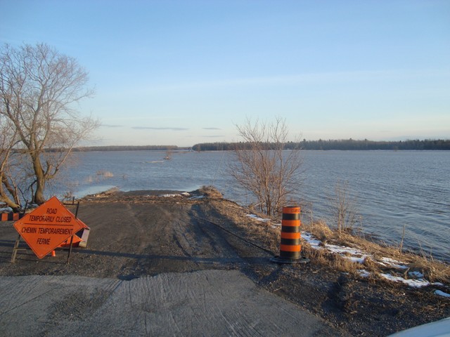
Hundreds of acres of farmers fields are flooded out and over the local roads
But the biggest thing that to take that has worked for five out of 13 flooded springs has been a mix of land grade and the berm, I have put the pigs to work and created wallow ponds to help fill and slow down the water movement in the valley that crosses over corner pasture and the big pasture, moving out into the little pasture.
The two high spots on the farm are the Big Barn and the house.. both are graded up compared to the rest of the farm’s land.. but it would not be enough without the berms.. I wish I had a photo of the Berm to show you what I mean but in the small pasture, someone? who owned this land created a two and half foot Berm that the water has to cross over but its on a natural slope that pushes it down the wall an that leads to a both a ditch that runs to the road ditches (or in really good floods, it is where we go canoe as it closes the road and is just a lake at the edges of our property,) When its not 150 plus acres of flood like that, it connects and drains into the setup at the end of that pasture that is tiled helping pull the extra water away, while my wallows and swells, help hold water the rest of the time on lean times.
I am thinking that I might want to talk to hubby and consider adding height to some of the ones that are already in place and I am wondering if I should be considering adding one along the big pasture side but If I do decide to that, I will have to hire someone to take a good hard look at it and make sure its built to specs and that it does not reduce water to my well..
And people wonder why I put up extra when I have good years 🙂


")
 (2)")
")
")


")

")

")
")


")
")
")


")
")
")
")

")


I love this line from the article …’The problems arising from this were manifold and certainly unforeseen.’ … all they had to do was ask the people who lived there before them, but that’s the trouble with colonisers, eh? 🙂
They just assumed they could cut it down and grow in it.. while it turned out to be anything but the truth.. granted if you have water and a source of impute, you can grow almost anything in sand, but only if you know how.. and that know how was certainly lacking
J > Geology, Geomorphology, Topography, History, Hydrology, River Engineering, Land drainage, Agricultural improvement – all in one blog post. And even hubby gets a mention! No wonder this post took some writing! BTW I now realize you’re not so far from KerryCan – near Lake Champlain, in fact. And now I know why I’ve always thought this an interesting area!
Just with a quick look at the map, I would say around 3 hours away give or take. Glad you liked the post.
Ok not that near, but in seen from 8k miles away, in the same neighbourhood! ;~)
Close enough to drive there and back on a tank of gas, by our big driving distance standards.. its day tripable 🙂
Wow, I knew that this part of Ontario was under water after glaciation (when the Great Lakes were all ONE great lake) but I didn’t know about the Champlain Sea. COOL! https://en.wikipedia.org/wiki/Champlain_Sea
Good idea about getting a hydrologist’s opinion – but even better for the previous owner’s aforethoughtful pre-emptive berming of the property!: )
We would’ve been under Lake Iroquois here… No wonder there are so many great fossil rocks around here: )
For sure, lucky you 🙂